An Arctic blast is poised to engulf Britain in the coming days, unleashing a 383-mile wall of snow and sending temperatures plummeting. As this frigid weather system approaches, a vast stretch of Scotland and northern England could find itself blanketed with up to 5cm of snow by Tuesday night. This comes as the country braces itself for the impact of a low-pressure system sweeping in from the North Atlantic.
The Met Office has issued a series of weather warnings, encompassing snow, ice, and high winds, for nearly all of Scotland, northern England, Wales, and Northern Ireland. Simultaneously, parts of the Scottish Highlands could experience temperatures as low as -10°C overnight between Monday and Tuesday, ushering in sub-zero conditions across most of Britain.
This icy air mass may provide optimal conditions for snow even in more southern regions. Weather charts suggest that some areas in southern England may see a few centimetres of snowfall by the end of the week.
The snowfall began in northern Scotland on Sunday, attributed to a surge of cold Arctic air causing chilly temperatures. A yellow weather warning for snow and ice remained in effect throughout Sunday and into Monday, covering regions including the Highlands, the Orkney Islands, and the Shetland Islands. The Met Office forecasts that parts of northern Scotland could receive around 10cm of snow over the next two days.
Northern Ireland is also anticipated to see up to 5cm of snow on higher ground during Monday, accompanied by a yellow warning extending from 3 a.m. to the end of the day.
Predictions suggest that snowfall may gradually extend southward during the week, possibly leading to wintry conditions in parts of northern England on Tuesday. While southern regions are considered to be at a “low risk” of snow, some weather charts hint at the possibility of a few centimeters of snow in southern England by Friday.
Met Office meteorologist Honor Criswick stated, “It is going to be feeling pretty chilly in the north of Scotland. Throughout the week, we are going to see more and more snow showers and warnings, towards the end of the week we will probably see an accumulation. The top temperature for Aberdeen is 2°C on Sunday, but it will probably feel cooler.
She went on to describe the progression of snowfall: “Snow showers will be moving inland throughout the course of the day. It continues all day Sunday into Monday, and we are likely to see an accumulation of snow and further warnings. We are going to see showers feeding across Scotland, Northern Ireland, and mainly the east coast of England.”
On Tuesday, rain is expected to turn into snow, advancing eastward across the country and causing more sustained snowfall, especially in the north of Scotland and northern England. These areas may receive 5cm to 10cm of snow at lower altitudes. While the likelihood of snowfall in the south is minimal, there is still a very low chance it may occur.
Southern regions are predicted to remain predominantly dry on Sunday and Monday, with the possibility of sporadic showers and a slight cloud cover. However, sunny spells should prevail with temperatures ranging from 7°C to 8°C.
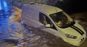
This bout of wintry weather comes as the nation recovers from the aftermath of Storm Henk, which inflicted considerable damage and flooding. PwC estimates that Henk caused around £150 million in insured losses to approximately 2,000 properties.
In addition to the snow and ice warnings, the Met Office has issued a separate warning for strong winds. The adverse weather conditions are expected to persist throughout the week.
The year 2023 was declared the warmest on record by the Met Office, with global temperatures reaching new highs. The worldwide average temperature last year rose to levels unseen since records began in 1850, surpassing the pre-industrial baseline by 1.46°C. This increase was primarily attributed to greenhouse gas emissions. Looking ahead to 2024, the Met Office predicts even warmer conditions, with global temperatures potentially exceeding the pre-industrial average by up to 1.58°C.
As the nation braces for this Arctic blast, residents are advised to stay informed about weather updates, heed official warnings, and take necessary precautions to stay safe during the wintry conditions.